What originally was planned by my brother and me to be a two day hike over about 70 miles with a sleepover at the midway location of High Point, NJ ended after about 18 miles into the trek on the afternoon of the first day. Well, we tried – and learned.
Raring to get as early as possible to the trailhead, we started off by cajoling the family to drop us off at the start point of the trail – located at the NY/NJ border. Starting at 6 in the morning, we started the hike by taking the 1.5 mile steep section of the blue blazed State Line Trail from the town of Lakeside in West Milford, NJ onto the top of Bearfort Mountain in the Abram S. Hewitt State Park.
The early morning walk up the mountain was especially breathtaking – the sun behind the trees, a bit of that hazy mist that surrounds damp trees in the morning, the birds just waking up and the occasional crack of dry branches in the distance signaling that startled deer. About 45 minutes into that climb, we spotted the white blazed Appalachian Trail at the NY/NJ state line. It was a mixture of emotions – elation at finally having reached the AT and a feeling that this was just the beginning of a long haul.
The trail itself was very well marked, the white blazes leading logically from one to the other with double blazes signifying a change of trail direction. Crossing split log bridges, woody roads, logs over intermittent streams, plank bridges over swamps and moss covered paths, we took in all that nature and the trail had to offer us that morning. We also noticed that the trail was slowly ascending gradually - up the Wawayanda Mountain. Named by the Lenape Indians, it means ‘winding waters’ and it tops off at about 1400 feet. In between, we stopped for a quick bite at Double Kill stream under an 1800's era iron bridge. Beauty. We also managed to get some water here before we resumed climbing the Wawayanda Mountain.
The views from the top of the mountain was moderate – nothing spectacular, but marked a little bit by a slight change in the nature of the vegetation around us – giving more ground to shorter and sturdier needle based woods than the sturdy hemlocks, white pines, balsam firs and spruces lower down. We also noticed large solitary rocks, the size of small trucks every once in a while, seemingly left there by a giant hand. These were remnants of the last ice age when glaciers carried these rocks downstream. Their current location must have been determined when certain sections of the retreating glacier melted faster than other portions, leaving large rocky detritus behind like isolated droppings of another age.
If climbing the mountain was difficult, descent was doubly so. The steep nature of the descent and the extremely rocky section of the trail were fairly hard on the knees and progress was very slow. In between, my brand new hiking shoes seemed to come apart at the soles (not too sure how this came to be as I got this from the supposedly venerable ‘Tent and Trails’ store in Manhattan - a store that I will never go to again).
The descent took about an hour, and the view on looking back at the now towering Wawayanda Mountain was especially beautiful. We felt in awe of the fact that we had managed to scale and descend our first peak in under 4 hours. Maybe we should have stopped and rested for a while at this point, but enthusiasm got the better of us and we decided to press on in spite of the complaining knee.
The scene in front of us was postcard perfect, Vernon valley and private farmlands were nestled between the Pochuck mountains upfront and Wawayanda behind. Most of the valley was covered with large wavy switchblade like grass overgrown with ferns, white / red sumac, buttonbush and violets. Along the long gravel path that led from the mountain base, we met a northbound thru-hiker who was on his way to Maine from Georgia. He went by the trail name Kit and said that this was his 105th day on the trail. We exchanged pleasantries and he seemed a bit taken aback that we were attempting the distance we planned in one day.
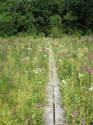
Vernon valley is basically swampy lowland and most of the trail over this section consists of intermittent wooden boardwalks built about 4 feet off the swamp surface. Years of flooding and vegetative growth along the Wallkill River on its way to join the Hudson created the Pochuck swamp over thousands of years. The floor of the swamp seemed mushy, soft and was covered with a rich, dark, brownish-black soil. The swamp itself was carpeted by a six feet high blanket of violets, yellow bellworts, poinsettias, daisies and a profusion of red flowers whose name I cannot seem to dredge. By this time, the afternoon sun was taking its toll and instead of stopping to rest, we decided to push on. I also remember reading that the boardwalk construction over the Pochuck swamp (also called Pochuck Quagmire) was one of the most expensive construction projects undertaken by the AT conservancy. The highlight of the walk across the swamp was a 14 foot high suspension bridge over the Pochuck Creek, whose foundation is said to float over the bog to make way for the shifting water and vegetation patterns.
It was about 12 noon when we decided to climb the 1100 foot Pochuck Mountain. The mountain was created out of billion year old rock and is scarred with ridges scraped from vestiges of the last ice age. The slope up the mountain was steep, unforgiving and beautiful. In between the climb, we caught sight of a baby deer who seemed to be fearlessly surveying us from behind the dense undergrowth. I also ran into our first rattlesnake along the way – I had decided to rest awhile and had just laid the backpack down on the forest floor when I heard an urgent clearing from the brush – and chanced on a snake about two feet long. We sized up each other for about 30 seconds before it decided to go along its way apparently deciding that I did not mean much harm.
After a little more climbing, we stopped for lunch (bread and meats) halfway up the mountain and I could feel my knee telling me that I will need to exercise better before trying anything of this magnitude in the near future. The rocks digging through the exposed sole of my left foot also was not really helping the situation. I remember cursing the lower Manhattan store multiple times. About this time, I decided that maybe we should call it a day and ask for help from the family in picking us right after we cross this mountain. It did turn out to be a wise decision.
The climb up Pochuck mountain was grueling, but the vistas on the summit was worth the effort. Wawayanda State Park and distant towns were tiny specks in the distance that was essentially covered in a maze of green that seemed to stretch as far as the eye could see. The distant reservoirs and the occasional lake reflected the brilliant blue of a cloudless bare Saturday sky. By this time, it was clear that we could not proceed any longer with my knee and the slipshod shoe. We asked for the family to come by and 'rescue' us from a designated point at the base of the mountain.
Descents are much harder than ascends for me and the descend down the especially steep Pochuck mountain was no exception. When one is tired, one does not seem to notice the beauty around the trail anymore – you just want to get to the next stop for whatever might be planned in terms of an end to the adventure. This was our condition on the way down. We however did stop a bit to heroically take a couple of pictures, but it was a feeble effort at maintaining a semblance of normalcy. On the way down, we ran into a 60 year old thru hiker who went by the trail name of Papa Rose. An interesting character, he offered several tips on finding water sources on the way ahead, and even mentioned that the mayor of the next town (Unionsville) was a kindly man who takes in hikers for the night at his home. We told him that this was valuable information, but we were calling it quits for the day.
In retrospect, we chewed off more than we could handle for a day. I also found out that hiking any more than 10-12 miles on the AT in a single day is inviting trouble, burnout and extreme stress on ones knees. Come to think of it, we had hiked about 18 miles in under 9 hours and ascended and descended 2 steep 1000 footers along the way. Nope, not a recommended idea, but at least we have a flavor for what lies in store ahead for future ‘section hikes’ across the trail. The plan still remains - section hike the trail end to end - even if it takes years - completion will happen at some point - cobbling a couple of days off from work every once in a while – cajoling family to pitch in – completing the trail wizened and intelligent.
The best part of the hike happened at the very end when my wife, her sister and my brother-in-law drove for a couple of hours to ‘rescue’ us on a fairly remote road (Lake Wallkill Road near the town of Owens, NJ). On thanking them for the effort mustered at short notice, their only response was ‘Hey, that’s what families are for…”
 The NY/NJ state line demarcated by the State Line Trail


2 comments:
That's quite an accomplishment, Sunil and it looks like you have a new respect for hiking!
By the way, that's not a rattlesnake. Believe me, I've met one in person and I know!
I was not too sure if it were a rattlesnake - made a best guess estimate there. Thanks for pointing that out. I have updated the text to reflect the doubts.
Thanks and yes, a new respect for the trail.
Post a Comment